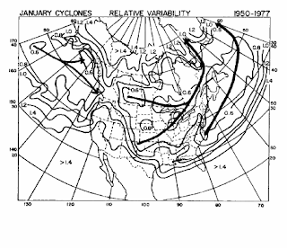
 Anticyclone center tracks for month of July for North America.
Source: (Zishka and Smith 1980)
 Anticyclone (high pressure) center tracks for month of January for North America.
 Cyclone center tracks for month of January for North America. Four main cyclone tracks are inicated according to their regions of origin:
 A jet is defined as any core of fast moving air, often indicated by a curved arrows on maps and by television meteorologists. The line is drawn in the location of the strongest winds. Jetstreams are typically wider and not as distinct, but more of a region where the wind increases toward a core of the strongest wind. One way of visualizing this is consider a river. The river's current is generally the strongest in the center with decreasing strength as one approaches the river's bank. It can be said that jetstreams are "rivers of air".
 Observation of winds from rawinsondes show that there are two principle regions in the upper troposphere where winds are strongest. The first is in the 50°-60° N/S region and is called the polar jet and is typically associates with the polar front. The second is called the subtropical jet and is located around 30°N. Jet streams vary in height of four to eight miles (about 500 to 200 mb) and reach a maximum at the tropopause, reaching speeds of more than 275 mph.
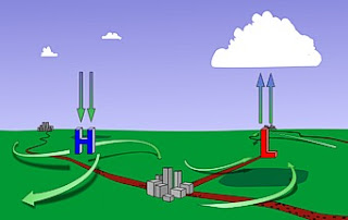
 Midlatitude surface systems consist of continental-scale high and low pressure systems.
| High (anticyclone) | Low (cyclone) | |
| 1. | a) clockwise b) outward c) downward | a) counterclockwise b) inward c) upward |
| 2. | downward circulation associated with clear conditions | upward circulation associated with cloud/precipitation |
| 3. | warm advection to west (left in picture) cold advection to east (right in picture) | warm advection to east (right in picture) cold advection to west (left in picture) |