Thursday, April 30, 2009

Overview of warm and cold front passage

Tuesday and Wednesday 27 and 28 April, 2009 saw temperatures fluctuate wildly as a warm and cold front passed over Vermont.The images at right document that passage (see Unisys archive for more maps).

At 0Z 28 April (Fig. 1) a warm front was slowly approaching from the west as soutwesterly winds brought warm, dry air from the southwestern desert states across New York State and into Canada.

Overnight, the warm front would slowly move across Vermont, and by 12 Z was located on the Maine-New Hampshire border (fig. 2). A cold front associated with the same Low pressure system over Quebec approached New England from the west.

This cold front would pass over Vermont within 6 hours, ushering in a much cooler air mass. By 0Z 29 April (Tuesday evening), the cold front had swept over Maine into the Atlantic (Fig. 3).

More links to graphics for this case can be found here.

Wednesday, April 15, 2009

Anticyclone center tracks for month of July for North America.

Source: (Zishka and Smith 1980)
Anticyclone (high pressure) center tracks for month of January for North America.

  • Most high pressure systems track southeastward across the middle of the continent from Alaska and the Yukon
  • Most anticycles end their track near Bermuda

Source: (Zishka and Smith 1980)

Cyclone center tracks for month of July for North America. Four main cyclone tracks are indicated according to their regions of origin.
  • Cyclones have a more northerly track mostly across northern Canada.
  • Cyclone tracks generally ends near Greenland and Iceland
Source: (Zishka and Smith 1980)
Cyclone center tracks for month of January for North America. Four main cyclone tracks are inicated according to their regions of origin:
  • Pacific lows
  • Alberta clippers
  • Colorado lows
  • Hatteras lows (Atlantic cyclones)
Source: (Zishka and Smith 1980)

Polar and subtropical jets

A jet is defined as any core of fast moving air, often indicated by a curved arrows on maps and by television meteorologists. The line is drawn in the location of the strongest winds. Jetstreams are typically wider and not as distinct, but more of a region where the wind increases toward a core of the strongest wind. One way of visualizing this is consider a river. The river's current is generally the strongest in the center with decreasing strength as one approaches the river's bank. It can be said that jetstreams are "rivers of air".

Observation of winds from rawinsondes show that there are two principle regions in the upper troposphere where winds are strongest. The first is in the 50°-60° N/S region and is called the polar jet and is typically associates with the polar front. The second is called the subtropical jet and is located around 30°N. Jet streams vary in height of four to eight miles (about 500 to 200 mb) and reach a maximum at the tropopause, reaching speeds of more than 275 mph.

The actual appearance of jet streams result from the complex interaction between many variables - such as the location of high and low pressure systems, warm and cold air, and seasonal changes. They meander around the globe, dipping and rising in altitude/latitude, splitting at times and forming eddies, and even disappearing altogether to appear somewhere else. Jet streams also "follow the sun" in that as the sun's elevation increases each day in the spring, the jet streams shifts north moving into Canada by Summer. As Autumn approaches and the sun's elevation decreases, the jet stream moves south into the United States helping to bring cooler air to the country.

Source: NWS

Midlatitude Surface systems

Midlatitude surface systems consist of continental-scale high and low pressure systems.

1. Can you summarize the three most important aspects of the wind circulation around high and low pressure systems?

2. What are the results of these wind circulations for cloud and precipitation formation of these characteristics associated with high and low pressure systems?

3. What are some the consequences of temperature advection associated with each of these systems?

Solution:


High (anticyclone)
Low (cyclone)
1.
a) clockwise
b) outward
c) downward
a) counterclockwise
b) inward
c) upward
2.
downward circulation associated with clear conditions upward circulation associated with cloud/precipitation
3.
warm advection to west (left in picture)
cold advection to east (right in picture)
warm advection to east (right in picture)
cold advection to west (left in picture)

Thursday, March 26, 2009

A greenhouse gas

Water vapor is a greenhouse gas, meaning that it absorbs outgoing longwave (IR) radiation and reemits it to the surfac of the Earth. The image at left shows the absorptivity of water vapor with respect to various wavelengths of ultraviolet, visible, and infrared radiation. Low values indicate transparency. For example, to visible light, water vapor is invisible. It is also almost invisible to the IR4 channel, the channel used to generate most IR satellite imagery. However, to wavelengths in the IR3 (water vapor) channel, about 50% of the IR is absorbed.

The IR3 channel is used to generate water vapor imagery. Please read the details at the following links:

Wednesday, March 25, 2009

Water vapor equilibrium

Given that water boils at 100 C (212 F) and that no place on Earth ever reaches that temperature under normal atmospheric conditions, an astute student might ask why there is any water vapor in the atmosphere at all? The answer is that just because the oceans don't boil, doesn;t mean there is no evaporation going on.

To picture and understand why, consider a "dry" atmosphere (without water vapor) above a warm tropical ocean at 300 K (27 C or 90 F) . Random motions will result in collisions between water molecules and with air molecules. There will always be some water molecules that pick up enough energy from these collisions to escape into the atmosphere. In other words, these water molecules evaporate, and the number of water molecules in the atmosphere increases, adding to the atmosphere's humidity.

At a certain point, because the energy of the system is limited, a number of water molecules in the atmosphere will begin to lose enough energy to condense back to liquid form. If condensation occurs in the atmosphere, falling precipitation will return the water to the ocean surface. Eventually, the atmosphere-ocean system reaches an equilibrium, where evaporation is balanced by condensation and precipitation. Here, the the atmosphere will become saturated with respect to water vapor, unable to sustain more water molecules. This balance occurs in the marine boundary layer, a small humid layer above the ocean or large body of water. Ascending updrafts are required to remove humidity from this layer to moisten the layer above the marine layer.

Adding heat to the system and increasing the temperature of the ocean (and atmosphere) to 305 K changes the equilibrium. With more energy, more water molecules will escape the ocean into the marine boundary layer, increasing evaporation. The number of water molecules in the marine boundary layer will increase. Because energy is still limited, precipitation and condensation increase to maintain a new equilibrium. Warmer temepratures mean a more active water cycle.

Global Water Reservoirs

This table shows that most water in the planetary system is stored in the world's oceans and polar ice. The atmosphere only holds a small fraction if the earth's water, mostly in the form of water vapor and cloud.

Note that rivers and streams contain less water than the atmosphere. This makes sense when you consider that rivers and streams are fed exclusively by water vapor in the atmosphere, so that the atmosphere actually represents an ultimate reservoir for rivers and streams.

Wednesday, March 18, 2009

Monitoring weather and forecasts


The following forecast for 12Z tomorrow morning map shows the evolution of the surface systems at this time.

You can monitor surface conditions for today by looking outside the window or using meteograms and observations at these two links:

Charts used in midterm


The following charts for this morning (12Z 18 March 2009) will be used for questions on the exam. We will be analyzing the effects of an approaching cold from associated with a low pressure system over northeastern Canada and a high pressure system over northwestern Canada.

Wednesday, March 11, 2009

Passage of a cold front: Meteogram

The following shows a meteogram for Barre/Montpelier from 2 UTC 11 March and 2 UTC 12 March, 2009 (10 PM Tuesday to 10 PM Wednesday). Wind barb and cloud cover symbols show southerly winds and overcast conditions early in the period. The temperature (top line in top panel) stays relatively constant at 35 F for most of the evening. With sunrise at 11Z the temperature gradually climbs to a little over 40 degrees at 19Z.

At 20Z (4 PM EDT) the clouds begin to dissipate and the winds begin to shift towards the west as the occluded/cold front moves in. The dewpoint (lower line on upper panel) plummets as drier air moves in, although the temperature actually rises to a sharp peak of 49 F at 22 Z. After this, cold advection takes over and the temperature begins to fall rapidly.

The pressure trace is also consistent with the passage of a low pressure trough. Precipitation occurs between 5Z and 13 Z early in the morning as pressures drop. Pressure bottoms out at 20Z with the arrival of the front.

Finally, the weathercam image for Wednesday shows how dramatically the frontal passage changes sky conditions. For most of the day, a low deck of clouds moves rapidly from right to left (south to north) across the screen. At around 21Z, the front arrives and the clouds rapidly dissipate. They also begin to move into the page, indicating that the wind has shifted to the west. The setting sun can be seen briefly lighting Burke montain and the underside of the dissipating cloud. Nice sunset.

Passage of cold front: Local Maps

Local maps for 18Z (2PM) and 0Z (8PM) show the eastward passage of the occluded front over Vermont. It transforms into a cold front during this period. The winds shifts from southerly ahead of the front to westerly behind the front.

The second cold front approaching the U.S. from Canada weakens during this period. The dashed cold front symbol means that the front is dissipating. Winds behind this front are strong, ranging from 10 to 20 knots. As temperatures are also considerably colder in this region (in the 10's and 20's) than over New England (40's), we can expect cold advection by the westerly winds to cause temperatures to fall at least to these levels.

Passage of cold front: Overview

Wed. 11 March 2009 analysis shows that the weather maker for the northeast is a deep low pressure system (central pressure 976 mb) moving over Northern Quebec. It is following a track typical for Colorado cyclones (see red arrow). The system formed east of the Colorad0 rockies on Tuesday evening, moving rapidly northeastward across Lake Superior to it's current position. An occluded front (purple) extends southward from the system into New York State at this time. An additional cold front extends to the Great Lakes. The counterclockwise circulation around the low pressure system indicates a northwesterly circulation behind the fronts, suggesting that the front will bring in colder temperatures to the northeast.

Thursday, March 5, 2009


The trace at left shows the effect of radiative disequilibrium between solar and terrestrial radiation ( (i.e. the imbalance between the intensity of visible and infrared light) on daily temperature variations. Note that it is very similar to current conditions as the graph is valid for the equinoxes (March 21 and September 21).
  • The green line shows the effect of solar radiation. It is only active after sunrise, peaks at noon, and dissappears after 6 PM.
  • The purple line shows the intensity of terrestrial IR radiation. It closely follows that of surface temperature (red line) since the amount of IR emitted by the earth is directly related to its temperature (Stefan-Boltzman Law).
  • The red shading shows the time of day when the incoming solar radiation is stronger than the outgoing longwave radiation (OLR). Because of this imbalance, the surface temperature increases during this period.
  • The blue shading shows the time of day when OLR is more intense than the incoming solar radiation. At this time of day, the surface temperature decreases.
  • Note that the peak temperature is reached when OLR and solar radiation are equal. This is usually about two hours after the solar noon (2 PM EST or 3PM EDT).
  • Note that the temperature drops most quickly early in the eveing and gradually tapers off to a minimum just before sunrise.
  • The temperature rises most quickly just after sunrise owing to the minimum in OLR intensity and the rapid increase in the intensity of solar radiation.
Note that the trace for LSC in the previous posting varies from the ideal situation depicted here. The cloud that pushed in around noon blocked out the sun, weakening the solar radiation and halting the temperature rise. The cloud also absorbs OLR, reemitting heat radiation back to the surface of earth early in the evening (see figure). This slows the dip in temperature early in the evening.

Sounding data for Albany, NY at 0Z 4 mar, 12Z 4 Mar shows that the daily temperature variation is in fact restricted to the very lowest layer of the atmosphere. At 0Z, the surface temperature at Albany is just about -8 C, whereas at 12 Z it has decreased to about -11 C. Note however, that above 950 mb, the temperature has barely budged. For example, at 950 mb the temperature remains constant at about -16 C.

This is typical of diurnal (daily) temperature fluctuations. These are restricted to a region of the troposphere called the boundary layer. Although the height of this layer can vary depending on weather conditions, it typically is restricted to below 850 mb. It's common to use temperature data from above this layer (usually 850 mb maps) to determine temperature trends based on temperature advection to remove the effect of the sun.

Data is taken from the University of Wyoming website.
The situation at 11 PM shows that winds have become calm over much of New England, with clears skies dominating the region as the high pressure system begins to dominate. Light winds and clear skies result in rapid temperature falls throughout the region. Where there is a weak wind, it tends to be westerly.

The time series below is for the last 24 hours at Littleton-Whitefield airport (click here for current conditions). Note that after 7 PM, with calm, clear conditions, that the temperature plummets by 26 degrees 15 F to -11 F as outgoing longwave radiation travels into outer space.


Time
EST (UTC)
Temperature
F (C)
Dew Point
F (C)
Pressure
Inches (hPa)
Wind
MPH
Weather
Latest Midnight (5) Mar 05 -6.0 (-21.1) -11.0 (-23.9) 30.26 (1024) Calm

11 PM (4) Mar 04 -2.9 (-19.4) -9.0 (-22.8) 30.24 (1024) Calm

10 PM (3) Mar 04 -0.9 (-18.3) -6.0 (-21.1) 30.23 (1023) Calm

9 PM (2) Mar 04 1.9 (-16.7) -2.9 (-19.4) 30.22 (1023) Calm

8 PM (1) Mar 04 8.1 (-13.3) 1.0 (-17.2) 30.22 (1023) Calm

7 PM (0) Mar 04 15.1 (-9.4) 3.0 (-16.1) 30.2 (1022) W 7

6 PM (23) Mar 04 18.0 (-7.8) 5.0 (-15.0) 30.18 (1022) NW 10

5 PM (22) Mar 04 19.9 (-6.7) 3.9 (-15.6) 30.15 (1020) WNW 15

4 PM (21) Mar 04 19.9 (-6.7) 3.9 (-15.6) 30.14 (1020) W 16

3 PM (20) Mar 04 21.0 (-6.1) 3.9 (-15.6) 30.13 (1020) WNW 16

2 PM (19) Mar 04 19.9 (-6.7) 3.9 (-15.6) 30.14 (1020) WNW 16

1 PM (18) Mar 04 19.0 (-7.2) 5.0 (-15.0) 30.15 (1020) W 10

Noon (17) Mar 04 18.0 (-7.8) 3.0 (-16.1) 30.17 (1021) W 12

11 AM (16) Mar 04 16.0 (-8.9) 1.0 (-17.2) 30.19 (1022) W 8

10 AM (15) Mar 04 12.9 (-10.6) -0.9 (-18.3) 30.21 (1023) WNW 5

9 AM (14) Mar 04 3.9 (-15.6) -0.9 (-18.3) 30.22 (1023) Calm

8 AM (13) Mar 04 -9.9 (-23.3) -11.9 (-24.4) 30.23 (1023) Calm

7 AM (12) Mar 04 -17.0 (-27.2) -23.1 (-30.6) 30.23 (1023) Calm

6 AM (11) Mar 04 -18.0 (-27.8) -23.1 (-30.6) 30.21 (1023) Calm

5 AM (10) Mar 04 -17.0 (-27.2) -22.0 (-30.0) 30.2 (1022) Calm

4 AM (9) Mar 04 -15.0 (-26.1) -22.0 (-30.0) 30.18 (1022) Calm

3 AM (8) Mar 04 -14.1 (-25.6) -20.9 (-29.4) 30.18 (1022) Calm

2 AM (7) Mar 04 -14.1 (-25.6) -18.9 (-28.3) 30.19 (1022) Calm
Oldest 1 AM (6) Mar 04 -11.9 (-24.4) -18.0 (-27.8) 30.19 (1022) Calm

Time
EST (UTC)
Temperature
F(C)
Dew Point
F(C)
Pressure
Inches(hPa)
Wind
(MPH)
Weather

Wednesday, March 4, 2009


The image at left is for 15Z (10 AM EST) Wed. March 4, 2008. New England is under the influence of a high pressure system over Virginia and a low pressure system over Northern Labrador. Animation loops at archived sites show that these are stationary systems. Note that the counterclockwise flow around the low pressure system reaches into New England leading to north-northwesterly winds. Animation for earlier in the week (see link) shows that this is the same system that brought the northeast coast over a foot of snow.
A closer look at New England at 21Z confirms a trough (dashed orange line) swinging through from the north. This elongated region of weak low pressure extends southward form the low pressure system over Labrador and explains the decrease in pressure and snow showers onserved over LSC in the afternoon. Temperatures directly to the north of Vermont are not appreciably different, but temepratures further to the northwest are slightly colder (in the mid teens). To the west of Vermont in western New York State and Ontario temperatures are slightly warmer. A slight change in wind direction to the west could lead to warm advection.

Temperatue and weather at LSC weather station


Weather summary for Wed. March 4, 2009 at LSC indicates the following high and low
Hi temp: 22.2F (-5.4C) at 13:55
Low temp: -11.7 F (-24.3C) at 06:10

Overnight temperatures were falling continuously (blue) before the low at 6:10 AM shortly before sunrise. This indicates a relatively clear night in which outgoing longwave radiation (OLR) was able to radiate into outer space without clouds interfering.

The sharp 30 degree rise in temperatures during the morning hours (red) indicates strong solar warming associated with clear skies and higher noontime solar angles.

Finally, temperatures in the early afternoon (green) are relatively constant in the lower 20's after about noon . Indeed, a slight dip in temperatures can be observed at around noon. The pressure trace shows a very slight dip (about 2 or 3 mb) in the pressure trace.

Comparison to temperature and pressure data shows a clear morning with light winds and a sudden appearance of snow over Burke Mountain around noon. This corresponds to pressure fall and constant afternoon temperature. Click here to retrieve larger image at webcam archive.

Thursday, February 19, 2009

The link at the image at left shows a 30 hour loop ending 0Z Thursday 19 Feb, 2008. It shows that the cloud over New England is associated with a low pressure system moving in from Colorado. Systems that follow this track are known as Colorado lows. They usually yield moderate precipitation, although this on seemed a little drier than usually. An occluded front (purple) extends southward from the low centered over Southern Ontario on 0Z Thursday. The warm front appears to further south. A cold front extends until the Texas coast. Ahead of the cold front, thunderstorms break out over the southeastern U.S.

A usual, the flow around the low is counterclockwise and inward. Note that southerly flow east the low pressure system brings moisture and low-level cloud northward. At the same time, the cloud deck appear to move in from the west as the jet stream moves the whole system eastward.

Local satellite images for Wednesday afternoon

The image at left shows the visible satellite at 21 UTC Wednesday, February 18 2009. Clicking on the image will link you to a a visible satellite loop of the entire afternoon after 17Z.

The loop shows thin, scattered cloud moving in early from the west. Later in the afternoon, a thicker, more extensive wave of cloud moves in, also from the west. This wave of cloud is the one that brought with it light snow.

The second image shows an IR image for the same time. It links to a loop of IR imagery. It confirms the double wave of cloud, and that the second wave appears to be more extensive. In addition, comparing the cloud shading to the temperature scale at the bottom scale at the bottom shows that the cloud tops have a temperature of about -40 C.

Current and archived imagery can be found at the UCAR's satellite page.

Wednesday, February 18, 2009

Wednesday's WeatherCam


The above WeatherCam image is for Wed Feb 18, 2008. The time in UTC is displayed at the top right of the animation. A larger animation can be viewed at the LSC Meteorology site webcam archive. It documents a weak storm system moving into the NEK and most of New England from the southwest. The camera faces eastward from the college campus towards Burke Mountain. Clouds moving into the page therefore mover from west to east, and those moving from right to left move form south to north.

The day begins with clear conditions and occasional high level cloud moving across the region from the northwest. Around 11 AM (16 Z) a mid level deck of cloud (at about 5 km or 15 000 feet)moves in from the west with the jet stream. Around 18Z. a lower, thicker deck of clouds moves in rapidly from the south. By sunset around 5 PM (22Z), this deck has lowered to the top of Burke Mountain (about 4000 ft). Snow begins to fall and obstruct the view of the mountain in the final few frames of the animation.

Wednesday, February 11, 2009

Local data

LSC data for Wed. 11 Feb. 2008 is posted in the image at right. the temperature reached a balmy 52.2 F (11.2C) at 14:45 in the afternoon. The dewpoint (purple line) rose consistently throughout the day as the air became more humid. The temperature (red line) fell and relative humidity (green line) rose abruptly at around 4 PM *(16:00 EST) . The dewpoint and temperature met at about 35 F as the relative humidity hit 100%, an indication of fog and precipitation.

The approach of the upcoming storm is announced by the increasingly sharp drop in pressure (blue line). The total drop in pressure appears to be about 15 mb for the day. Winds actually appear to have died down in the evening after peaking in the late afternoon.

Data from Littleton/Whitefield Airport, NH (HIE) confirms a high of 52.0 F and the onset of rain and fog at about 5 PM EST. A similar plunge in sealevel pressure is also observed. The rain gauge detected 0.10 inches of precip before 0Z (7PM EST).

Local precipitation

A close up of the situation over the northeast U.S. at 1Z Thursday 12 Feb, 2008 confirms a broad zone of overcast skies and light rain to the north of warm front cutting right across central New England and New York. In addition, Morrisville, VT (MVL) reports fog and Mount Washington, NH (MWN) reports freezing rain. Winds are either calm or from the southeast.

In contrast, behind the front in Massachusetts and Connecticut winds are southwesterly, with some stations actually report clear skies.

You link to the map of local stations to locate relevant stations.

February showers

Today's rain is associated with a low pressure system and associated warm front moving in from the southwest. On the surface analyses for 12 Z (7AM) Wednesday 11 February, 2008 (left) the low pressure system was located over the center of the U.S. A warm front extended northeastward into West Virginia. A south-southesterly flow ahead of the storm system (red arrows) transports warm, humid air from the Gulf towards the warm front. Meteorologists refer to this flow as a vapor channel. The humidity falls as precipitation to the north of the front (black circle). This is typical of of midlatitude winter storms. Light to moderate precipitation typically falls in broad regions north of warm fronts to the northeast of the low pressure center.

By 00Z Thursday 12 Feb. 2008, the storm center has moved into the Ohio valley. The vapor channel from the Gulf of Mexico is cut off by the cold front moving eastward across the southeastern states. Moist air from the Atlantic continues to stream northward ahead of the storm system (red arrows). Precipitation continues to fall ahead of the warm front (shown as a stationary front over northern New England (black circle).

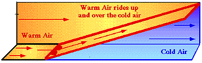
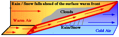
This precipitation occurs because warm humid air overruns the cold air ahead of the front when it reaches the front. This leads to cloud formation and precipitation. This falls ahead of the front as frozen precipitation if the surface temperature is below freezing and rain of the surface is above freezing. See "Precipitation along warm front" tutorial for more information.

Thursday, February 5, 2009

Record cold for Feb 5?

Record low for Saint Johnsbury is -36 F. It is currently -6 F as of 1 AM. We're not even close.

Wednesday, February 4, 2009

High pressure system and eastern cold surge

The image at right is for 0Z Thursday 05 Feb
2009 (7PM EST Wednesday 04 Feb 2009). A line of high pressure systems over the eastern U.S. dominates the eastern half of the continent. A line of high pressure centers is called a ridge. The circulation around this ridge is clockwise and outward. This means that to the east of the high the winds blow from northwest and push in cold air (blue arrows). To the west of the highs, winds blow from the southeast (red arrows). Note that the cold arctic air is transported all the way to southern Florida behind a cold front. The temperature at Savannah Georgia is approaching freezing (36 F).

The second image shows a forecast valid one day later at 0Z Friday 06 Feb 2009 (7PM EST Thursday 05 Feb 2008). The high pressure centers have moved southeastward to the Florida panhandle. The associated ridge to the north shifts eastward, extending across New York State into Canada, indicating that pressure over Vermont and New England will continue to rise. Cold northwesterly winds will continue through all of Thursday. A low pressure system forms over southern Alberta (an Alberta clipper!).


The third image shows a forecast valid two days later at 0Z Saturday 07 Feb 2009 (7PM EST Friday 06 Feb 2008). The high pressure system has moves souteastward to the coast of northern Florida. As a result, a south or southwesterly wind now dominates much of the eastern part of the U.S., bringing with it warmer air. It appears that this will warm up temperatures over the weekend starting Saturday morning.

The dark black arrow indicates the path of the Alberta Clipper moving into the Dakotas from southern Alberta. The counter clockwise circulation around the low enhances the southerly winds to the east of the system. This low pressure system will bring it with cloud and light precipitation as it moves rapidly across the continent this weekend.

Cold air and high pressure

The trace of weather data from LSC for Wed. Feb 5, 2008 indicates rising pressures and falling temperatures. As of 10:30 PM, the temperature is already -3 F, colder than the overnight low of 2 F the previous morning. The pressure trace shows a rise in pressure to about 1015 mb currently from about 10 mb from 1005 mb at midnite the previous evening. (Note however that the pressure values are low compared to other stations, indicating possible problems with the barometer). In the bottom panel, sustained winds (blue) and gusts (purple) become calmer and calmer as the high pressure moves in.