 LSC data for Wed. 11 Feb. 2008 is posted in the image at right. the temperature reached a balmy 52.2 F (11.2C) at 14:45 in the afternoon. The dewpoint (purple line) rose consistently throughout the day as the air became more humid. The temperature (red line) fell and relative humidity (green line) rose abruptly at around 4 PM *(16:00 EST) . The dewpoint and temperature met at about 35 F as the relative humidity hit 100%, an indication of fog and precipitation.
The approach of the upcoming storm is announced by the increasingly sharp drop in pressure (blue line). The total drop in pressure appears to be about 15 mb for the day. Winds actually appear to have died down in the evening after peaking in the late afternoon.
 Data from Littleton/Whitefield Airport, NH (HIE) confirms a high of 52.0 F and the onset of rain and fog at about 5 PM EST. A similar plunge in sealevel pressure is also observed. The rain gauge detected 0.10 inches of precip before 0Z (7PM EST).


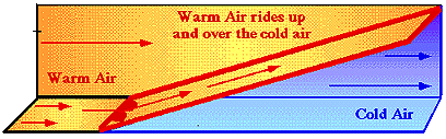
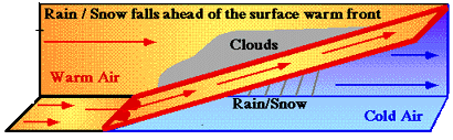 This precipitation occurs because warm humid air overruns the cold air ahead of the front when it reaches the front. This leads to cloud formation and precipitation. This falls ahead of the front as frozen precipitation if the surface temperature is below freezing and rain of the surface is above freezing. See "